
Since the US-Israeli attack on Iran, the whole world has been obsessing over the Straits of Hormuz. Now the troubled economy of Germany has another waterway to worry about: The Rhine.
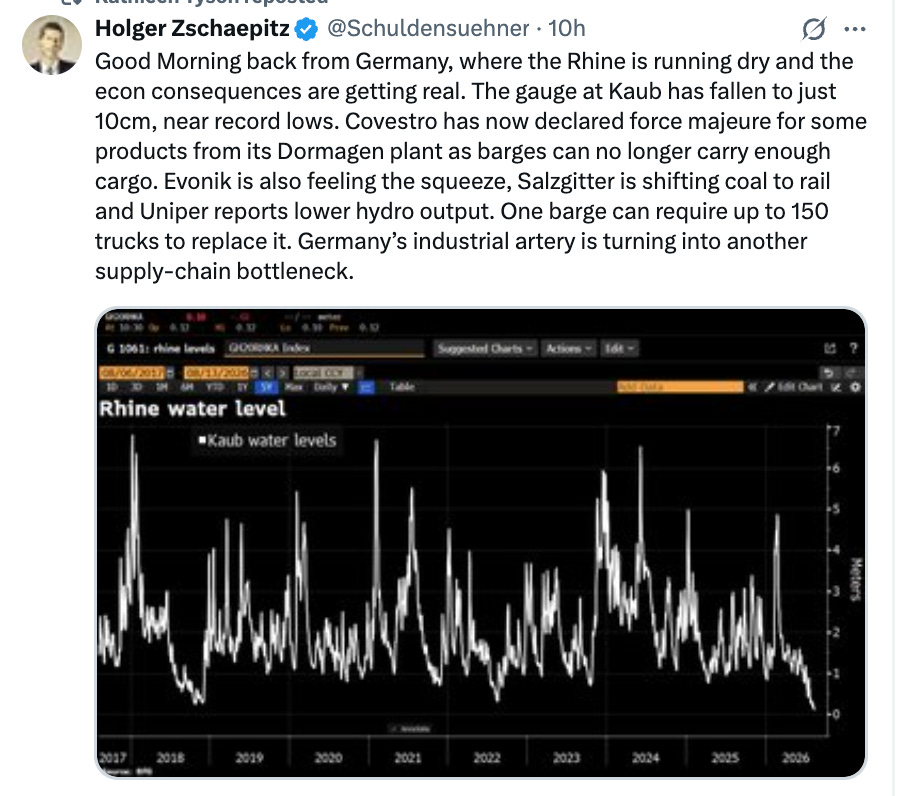
Holger Zschaepitz has the news from German business on the Rhine as of August 13th.
The Rhine river carries roughly 80 percent of the 223 million tons of cargo that are transported by ship in Germany each year. That is only 5 percent of total freight traffic. But it is heavy stuff - oil, petrochemicals and the like. And the alternative connections from West Germany’s industrial heartland to Belgium, the Netherlands and the North Sea are more expensive.
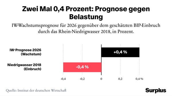
As highlighted this week in Surplus magazine - the progressive economic magazine I helped to publish in Berlin - a large disruption of the Rhine riverway, on the scale of the 2018 drought, could be enough to negate any growth in the German economy this year.
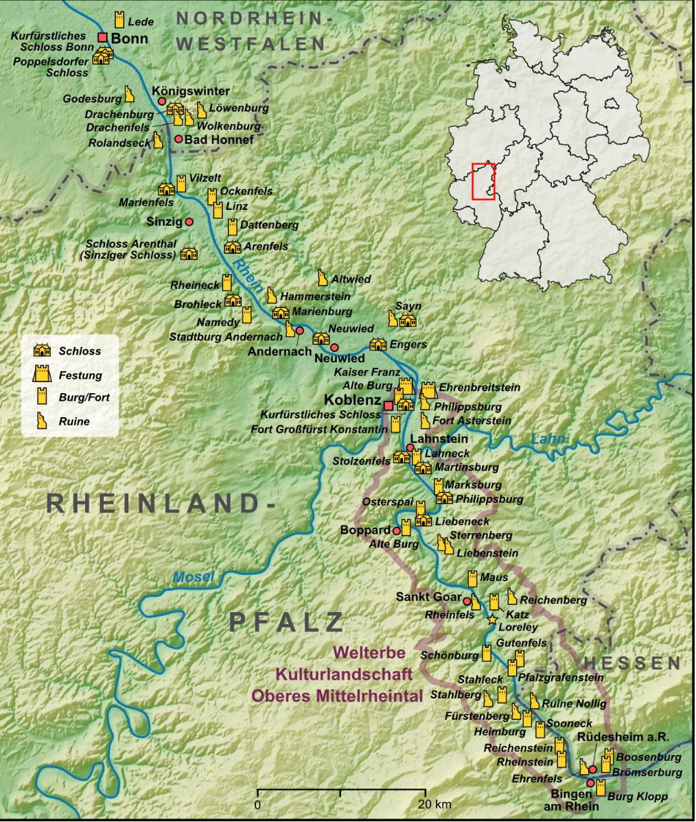
The river passage is at its tightest in Hesse, north of Frankfurt around the famous rocks of the Loreley, the site of Germany’s very own siren myth.
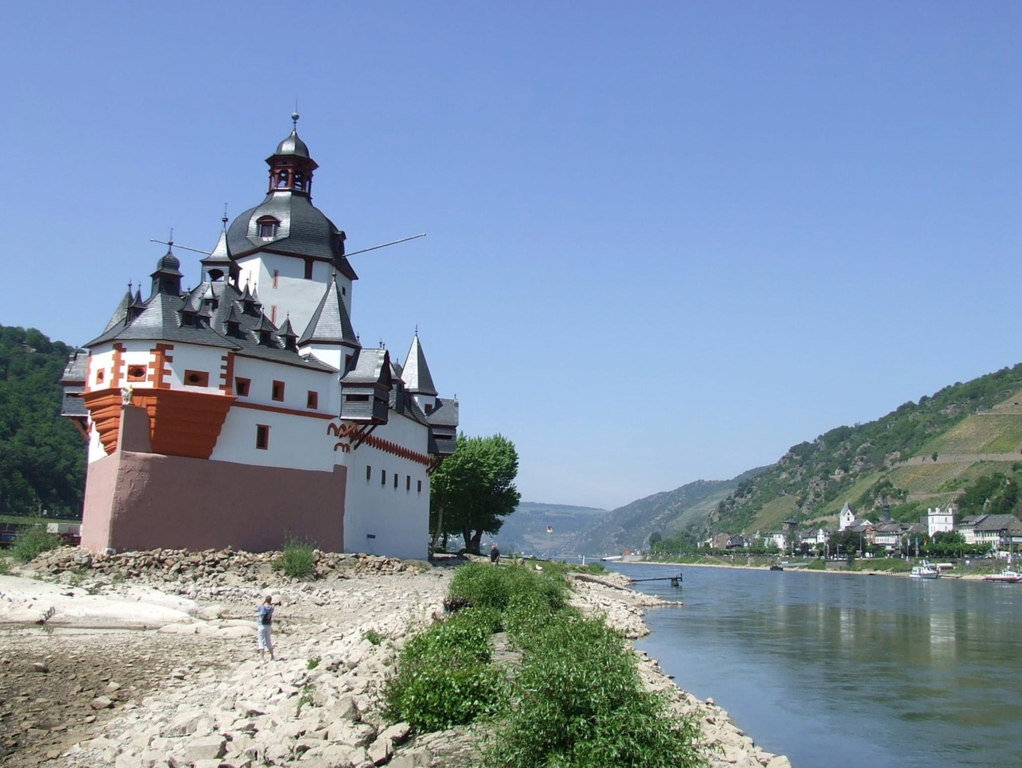
The most severe choke point is at the small town of Kaub situated on the right bank of the Rhine (going downstream). And this narrow is marked by the picturesque castle of Burg Pfalzgrafenstein which from 1327 had the job of leveraging the rocky formation it stood on, to impose a toll on river traffic. The job of the fearsome armory of catapults and cannon mounted on the high walls of the castle was to force passing Rhine river traffic to pay tolls in Kaub. The choke point was particularly tight because upstream of the Pfalz the left bank was made impassable by rapids. Exploiting this geographic feature Ludwig the Bavarian, Pfalzgraf of the Rhein had construction on the tower begun in 1326. It survives to this day, now topped with Baroque rooves.
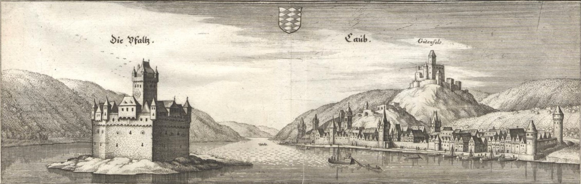
Die Pfaltz bei Caub from Merian’s (Topographia Palatinus Rheni, 1645).
Merian’s image shows a structure very much like the one we see today, with the added feature of a prowlike fortification wall, which was added in the early 1600s after the less streamlined medieval fortifications had been repeatedly damaged by ice flows. The extra wall space allowed even more cannons to be added. For those refusing to pay tolls, the castle featured a dungeon whose inmates saved from drowning at high water, by a floating wooden floor.
Heading down river Pfalzgrafenstein was the first in a gauntlet of castles and toll posts that all sought to exploit the Rhine waterways for taxing purposes.
In 1813/1814 the Kaub passage was used by General Blücher to cross an army of 60,000 troops, 20,000 horses and 200 guns in hot pursuit of a retreating Napoleon. And throughout the first half of the 19th century Kaub continued in roll as a toll point.
At the Congress of Vienna in 1815 the issue of overcoming the multiple obstacles to Rhine navigation as a common interest of the European powers had first been broached, leading to the creation of a Central Commission for the Navigation of the Rhine and in 1868 to the Convention of Mannheim signed on October 17, 1868. In 1867 after Prussia’s dramatic defeat of the Habsburg Empire and its German allies, both sides of the Rhine were firmly in Prussian hands and, half a millenium after they began their activity, the last toll officials finally left Kaub and the castle of Pfalzgrafenstein.
With the tolls gone, all that remained were the rocks and the castle, which down to the 1960s served as a signalling station for Rhine traffic and increasingly as a tourist attraction. The rocks are scenic, so long as there is enough water in the channel. But when the water is shallow that rocky protuberance becomes rate limiting for one of the major logistical arteries of the European economy. It is still there today, with the prowlike walls facing upstream and now starkly exposed by the low water level.
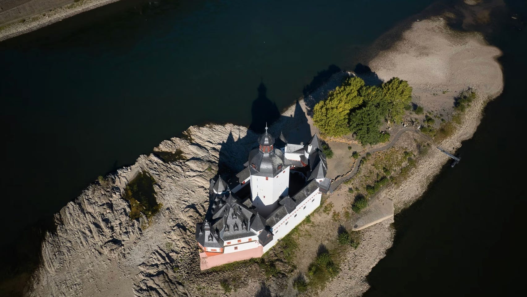
And in the year of our lord 2026, it is, once again, Kaub that forms the bottleneck in the Rhine.
But, surely, you say, rocks can be moved? Promontories can be shaved off? Can’t they? After all the modern Rhine river is “man-made” “second nature” from start to finish.

Well yes, but then it turns out that it is not just physical nature that is obdurate.
As Olaf Storbeck reports in the FT this week:
Germany’s shipping industry has hit out at Berlin for dithering for 34 years over a project to deepen the Rhine river at a critical chokepoint, as historically low water levels in the area disrupt supply chains and threaten to damp economic growth. Back in 1992, the government of Chancellor Helmut Kohl vowed to remove submerged rocks in the Rhine just south of the mythical Loreley, a towering slate cliff where — according to an old legend — a siren lured ships on to the rocks. But 34 years later, the shallow passage still creates a major bottleneck for shipping on Germany’s largest and most important waterway, which accounts for 80 per cent of inland shipping. Near the town of Kaub to the west of Frankfurt, the navigation channel is 20 centimetres shallower than elsewhere, often forcing ships to reduce their load if water levels fall. … The crisis has shone a spotlight on why the rocks’ removal has been delayed for so long. “It’s just inscrutable why it takes so long to plane off six underground sections of rock,” Jens Schwanen, chief executive of Germany’s association of inland shipping (BDB), told the FT. Schwanen believes the engineering work to remove the submerged rocks would only take about eight months. But it is emblematic of Germany’s wider infrastructure crisis. “We are wasting time that we don’t have,” Schwanen said.
Can this be true, you ask? Oh yes it can! Turn to google and I invite you to visit the webpage titled:
As it rather blandly declare: “at low and medium water levels … the economics of river traffic are decisively rate limited by this section of the Middle Rhine. The project of optimizing the channel therefore counts amongst the Federal water way projects with highest priority.” Which means?
“As scientific advisors the BAW is advising the water way and river traffic officde of the Rhine with riverine construction, nautical, geotechnical and hydrological expertise. In the course of planning and evaluation of riverine engineering measures were are applying innovative methods, for instance the combination of numerica and analogue transport models … “
Which sounds fascinating, but the people that the FT talks to are not satisfied:
Attempts to deepen the navigational channel have been much delayed by a combination of factors including environmental objections, shifting political priorities among various German governments and the country’s lengthy planning process. While the deepening was again made a political priority in 2019 after low water levels the previous year dented German GDP, the current plans still imply the work will only be carried out by 2033. Germany’s Federal Waterways Engineering and Research Institute has called it a “highest priority” project. Federal transport minister Steffen Bilger said on Wednesday that Berlin was “pressing ahead” with the deepening of the Kaub section, adding that the work was a matter of overriding public interest. After a recent change in German planning law, the approval process for such projects has been simplified and streamlined. However, the transport ministry did not respond to an FT request as to whether the timetable could be brought forward from 2033. … Bernd Reuther, a former MP for the pro-business Free Democrats, is just as frustrated as the shipping industry. “It’s just a never-ending story that has been with me for many years,” he said. In 2019, Reuther filed a motion to parliament to expedite the work on the riverbed, describing the project as “one of Germany’s most important transportation projects”. He warned then that the goal at the time to finish the deepening by 2030 was at risk — a prediction that proved prescient. … “The Kaub section [of the Rhine] has in effect turned into Germany’s Strait of Hormuz,” ING’s global head of macro Carsten Brzeski told the FT … While the disruption in Germany has not been caused by military conflict, it is “once again an example of infrastructure that has not been properly maintained”, said Brzeski, adding that German policymakers for too long took natural infrastructure like waterways and rivers “for granted”.
But, hang on, you say to yourself: Isn’t the problem a lack of water? How is digging a deeper channel going to help? It isn’t going to add any more water.
And, of course, you would be right. What Rhine traffic needs, in general, is not deeper channels but more water in those channels! The debate in Germany is getting technical! ;)
As this excellent (jokes aside) piece by Martin Jendrischik points out, there is something akin to a culture war going on in the debate over Rhine navigation:
A deeper navigation channel does not bring an additional liter of water into the river. … The less obstructed the water is able to flow, the faster it leaves the affected sections toward the North Sea. What benefits individual cargo vessels in the short term is therefore missing elsewhere in the system in subsequent dry years.
“Doesn’t make any sense at all”: That is how Markus Neumann of the Waterways and Shipping Office for the Rhine assesses the deepening of the navigation channel in an interview with ntv. His argument is that the shape of the riverbed has morphological causes. If you simply dredge without changing these underlying conditions, the original state returns after a relatively short time—the same shallow depth as before.
As an alternative, the agency proposes deliberately narrowing the navigation channel, for example with so-called low-water groynes, (rigid, wall-like structures built perpendicular to the shore into the ocean or a river bank. Made of wood, concrete, or stone, they stop sand and sediment from moving away) which concentrate the remaining water and thereby raise the water level. The fundamental difference from deepening is this: narrowing the channel actually creates greater depth from the same amount of water, whereas dredging merely enlarges the cross-section that the scarce water then has to fill. “Deepening or optimizing a navigation channel can increase the usable water depth, but it does not create any additional water,” Boris Lehmann, a water engineering researcher at TU Darmstadt, told the Science Media Center. Recurring sediment deposits also mean that dredging is not a permanent solution.
Just how much the Rhine riverbed is shifting is illustrated by a construction project that began this week on the Lower Rhine. The Waterways and Shipping Office for the Rhine is having sand-and-gravel mixtures placed into the river between Niederkassel and Niedermörmter over a period of 13 months, at a cost of around €7 million. The reason is that the straightened Rhine receives too little natural sediment from upstream and is therefore cutting ever deeper into its own bed, endangering riverbanks, structures, and habitats. The German federal government is thus currently paying to slow the Rhine’s uncontrolled incision, while in Bonn there is debate about additional dredging. … The real causes lie elsewhere. Climate change is bringing too little precipitation and too little snow to the Alps, meaning that in summer there is not enough meltwater to feed the Rhine for weeks at a time as it normally does. Added to this is a drainage infrastructure of pipes and ditches that rapidly channels what little rain there is toward the sea, compounded by river courses that have been straightened over centuries, depriving the water of every natural buffer.
The same heat that causes water levels to fall is simultaneously putting pressure on agriculture along the river. That Europe’s summers are drying out faster than climate change alone would explain has already been demonstrated by a recent circulation study using the Rhine as a case study.
But even the skeptics admit that at Kaub, the rocks are an issue:
Kaub is considered a bottleneck because a natural rock ledge narrows the river cross-section there, which is why the water level at Kaub serves as a reference level for shipping on the entire Rhine.Targeted deepening at such bottlenecks can help more ships pass through. General deepening, however, accelerates the outflow and thereby exacerbates water shortages downstream.
The FT’s contacts in industry agree
“As a result, maintenance and modernization were neglected,” he added. In the long run, deepening the Kaub section in itself will not be “a panacea,” as shipping will still have to be suspended if the water level falls below a critical threshold, said BDB’s Schwanen, adding that active water management, including a system of locks, will become necessary. “But ships would have been able to keep operating for longer and would not have become stranded so early,” he said.
So what might provide a broader solution? Martin Jendrischik canvasses a range of options.
A funding program for low-water vessels with shallow drafts addresses the actual weak point. Many of the old cargo barges on the Rhine need to be replaced anyway because of their climate-damaging propulsion systems. New vessels with clean propulsion and shallower drafts would combine climate protection and climate adaptation in a single step.
An example from practice shows how shallow a vessel’s draft can technically be: Cologne’s fireboat reportedly operates with a draft of around 60 centimeters. Even specialized cargo vessels, however, quickly encounter limits. The tanker Stolt Ludwigshafen, built specifically for BASF since 2023 to operate during low-water conditions on the Rhine, needs at least 30 centimeters of water level at Kaub just to operate, and even with a one-meter water level it can carry only half its cargo. For the cargo fleet, therefore, conversion is primarily a question of economic viability. Shipyards first have to develop, build, and finance such vessels; this cannot happen overnight.
So far, the federal government has provided €10.5 million in funding to convert exactly three cargo vessels into low-water-optimized ships, a ministry spokesperson confirmed on Monday. Thousands of inland waterway vessels operate on the Rhine. At this scale, the program remains a gesture rather than the beginning of a fleet renewal. The program will only become effective when tenders require shallow draft and low-emission propulsion together.
… The third lever is rail. Cargo that is currently stranded on the waterways could switch to rail if the rail network had the capacity to handle it. So far, the shift has often failed because of a lack of rail connections and shunting capacity at ports, not because shippers are unwilling to make the switch. The special infrastructure fund offers an opportunity to finally make up for this expansion, which has been delayed for years.
All three levers require time, whereas the navigation channel could be dredged comparatively quickly. This temptation of taking fast, visible action makes deepening politically attractive, even though it does not solve the underlying problem.
These are obviously weighty and fundamental issues. There are no simple solutions. But returning to the Rhine and to Kaub, one can’t help wondering what a late-medieval potentate like “Ludwig the Bavarian”, Pfalzgraf of the Rhein would have thought of a society such as Germany today, seven hundreds years later, rich beyond his wildest dreams, but still stumped by the rocks at Kaub on which he built his toll tower, bristling with catapults and cannon.
As they say in the real estate business: location, location, location.
I love putting out Chartbook. I am particularly pleased that it goes out for free to thousands of subscribers around the world. But, writing this newsletter takes a lot of work. If you are enjoying it and would like to support the project, sign up for one of the subscription options here. It is the equivalent of a fancy cup of coffee per month!
No posts
Comments
Nothing yet. Say the first thing.
Sign in to join the conversation.